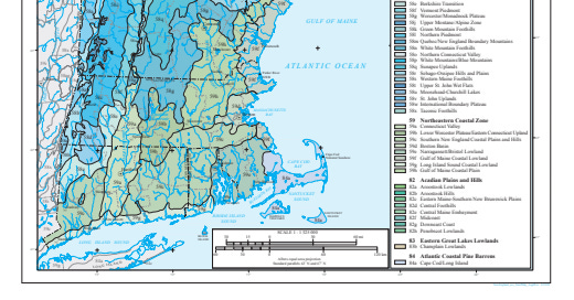
The Ecoregions of Plymouth County
The Gulf of Maine Coastal Lowland, the Narragansett/Bristol Lowland, and the Atlantic Coastal Pine Barrens
[ Readers, another adapted excerpt from my doctoral dissertation, the continuation of last week’s discussion, moving from geology to ecology in Plymouth County. I apologize for the relative dearth of activity this week, I am in the middle of kith-and-kin activity and am a bit scattered of late. Mea culpa! And now, the ecoregions of Plymouth County! ]
Plymouth County is divided into several ecological regions. The northernmost portions of the county, places like Hingham and Hull, are included in the Boston Basin, around Boston Harbor, and in the Southern New England Coastal Plains and Hills region.
The vast majority of the county, however, is encompassed by three ecoregions: the Gulf of Maine Coastal Lowland in the northeast, the Narragansett/Bristol Lowland in the center and west, and the Atlantic Coastal Pine Barrens in the south.
( Ecoregions of New England. On the map, 59f, in beige, is the Gulf of Maine Coastal Lowland; 59e, in a greenish shade, is the Narragansett/Bristol Lowland; and 84a, in a purplish hue, represents the Atlantic Coastal Pine Barrens. Photo credit — Wikimedia Commons. )


